Great Lakes Research Consortium
Lake Ontario - Sodus Bay, NY

Greater Sodus Bay is located along the south shore of Lake Ontario. The bay is located in Wayne County, New York between the Towns of Huron and Sodus. The Village of Sodus Point is located at the northern end of Sodus Bay.
Status: Buoy has been removed for the season.
Central Basin
Maintained by SUNY College of Environmental Science and Forestry
43.253 N, 76.963 W
The Sodus Bay buoy system consists of three NexSens Technologies MB-300 lake buoys. Each buoy communicates to the GLRC via a cellular modem and is powered by three solar-charged battery packs. The center buoy is located in approximately 30 feet of water in the deepest part of the bay. This buoy is equipped with a weather station measuring air temperature, wind speed and direction. A temperature string measures water temperature from surface to bottom in approximately 4 ft intervals. Depth, dissolved oxygen (ODO) and specific conductance is measured via separate YSI sensors located approximately 3 feet below the surface and 3 feet above the bottom. The MB-300 is also capable of supporting additional in-water sensors. We currently are testing a number of different probes for chlorophyll, phycocyanin, turbidity, and water clarity at the north and south buoys. This information is not publicly available at this time. Further information on these buoys and any additional information that may be available can be requested from the GLRC at [email protected].
The Sodus Bay buoy system is deployed in mid-May and retrieved in mid-October. In water data from these buoys is not available outside these dates. Weather information from shore stations may be available if technology is permitting. Funding for this buoy comes from the Great Lakes Research Consortium (GLRC), The Great Lakes Observing System (GLOS), USEPA via the Great Lakes Restoration Initiative (GLRI), New York Sea Grant, and from SUNY-ESF. We wish to acknowledge the support and help from Save Our Sodus (SOS) Inc. and the many concerned citizens that use the bay.
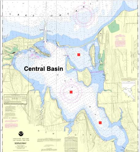
Source: NOAA online Chart viewer
Disclaimer: Data published on this website is not intended to be used for navigational or operational purposes. Due to atmospheric or other conditions, latest data may not be available.