Center for Cultural Landscape Preservation
Research

Cultural landscape preservation has been the subject of research in the ESF Department of Landscape Architecture for over two decades.
Research projects sponsored by the Center provide students with experience on actual preservation planning projects, mostly for state and national parks, along with non-profits in the Central New York Region. Other research has focused on exploring methods and theories of cultural landscape preservation. Students have used Center research to fulfill academic requirements, such as through design studios, independent studies, and internships. Many of the projects have been finalized into reports published through the department’s partnership with the National Park Service Olmsted Center for Landscape Preservation.
While detailed methods and content for each research project depend on the subject landscape and its historic contexts, most have followed methods for all or part of three types of planning reports used in the National Park Service. These reports pertain to the broad preservation objectives of identification, evaluation, and management (treatment).
- Cultural Landscape Report (CLR): A CLR is a comprehensive management document for a cultural landscape. It includes a site history that documents the physical development of a landscape; an existing conditions chapter that documents the current state and use of the landscape; an analysis and evaluation chapter that organizes the landscape into characteristics and features to assess significance and historic character based on criteria established by the National Register of Historic Places; and last, a treatment section that details changes necessary to enhance the landscape's historic character and contemporary use in keeping with the Secretary of the Interior's Standards for the Treatment of Historic Properties.
- Cultural Landscape Inventory (CLI): The CLI is a computerized, evaluated inventory of all cultural landscapes in which the National Park Service has or plans to acquire any legal interest. Its purpose is to identify cultural landscapes in the system and provide information on their location, historical development, character-defining features, and management. The CLI assists park managers in planning, programming, and recording treatment and management decisions.
- Historic Resource Study (HRS): A HRS is a general history document that assess physical resources including cultural landscapes, buildings, and structures. It provides an historical overview of a property or region, and identifies and evaluates its cultural resources within historic contexts. The HRS supplies data for resource management and interpretation through documentary research and field investigations to determine and describe the integrity, authenticity, associative values, and significance of resources.
(Source: Adapted from NPS-28 Cultural Resource Management Guideline)
The following list of research projects provides brief summaries, hyperlinks to the digital document where available, or call number for the hard copy at SUNY ESF Moon Library. Some of the projects are not available in either digital or hard copy. Graphics may not be reproduced without permission of the owner or author, unless cited as from a public source. Other information may be used provided full credit is given to the authors and publisher, as appropriate.
Current Research Projects
Cultural Landscape Reports
Marin County, California
This project is documenting the history and existing conditions of the Muir Woods
park landscape, evaluating its historic character, and developing treatment recommendations
to guide long-term management of the cultural landscape and several upcoming improvement
projects. The project will build off research completed in 2008 for a historic resource
study of Muir Woods (see published reports).
Auburn, New York
This project is developing the first landscape management plan for the newly-created
park, established in 2017. The park is a mix of NPS-owned land (Thompson A.M.E. Zion
Church) and private land (Harriet Tubman Home and Tubman Farm properties owned by
the A.M.E. Zion Church and managed by Harriet Tubman Home, Inc). The project is documenting
the history of the three properties in the park along with the Tubman gravesite in
Fort Hill Cemetery, evaluating the historical significance and integrity of the landscapes,
and developing treatment recommendations to guide the transition into a unit of the
National Park System. A thematic studio was held in spring 2017 to develop preliminary
treatment concepts. The Center is also providing ongoing technical assistance to the
park to guide its transition.
Gettysburg, Pennsylvania
This project is documenting the history and existing conditions of the 800-acre 1st
Corps Battlefield, a palimpsest of the rural 1863 battlefield landscape and the designed
commemorative park landscape built under the War Department between ca. 1885 and 1920.
A comprehensive evaluated inventory of all landscape characteristics and features
will be followed by treatment recommendations intended to address preservation and
restoration of the historic landscape. A focus of the treatment recommendations is
the 95-acre former Gettysburg Country Club property acquired by the park in 2011.
Orange County, Virginia
This project is documenting the historical and existing conditions of the 2,000-acre
site of the May 1864 Battle of the Wilderness, and inventorying and evaluating its
cultural landscape characteristics and features. The battlefield is today a discontiguous
collection of lands acquired by the federal government beginning in the 1920s and
1930s. Suburban development has encroached on a large part of the surrounding area.
The project follows a Cultural Landscape Report for the adjacent Chancellorsville
Battlefield completed in 2018.
Fredericksburg, Virginia
This project is documenting the history and existing conditions of the Civil War-era national cemetery, inventorying and evaluating its landscape characteristics and features, and providing treatment recommendations to preserve and enhance the cemetery's historic character. This is the third Cultural Landscape Report undertaken by the CCLP for Civil War-era national cemeteries in the National Park System. Reports for Poplar Grove National Cemetery (Virginia) and Gettysburg National Cemetery were completed in 2009 and 2016.
Cornish, New Hampshire
This project is documenting the history and existing conditions of a forty-acre portion
of the historic Beaman-family country place along the Connecticut River that was acquired
by the National Park Service in 2010. Historic landscape resources, including a large
19th-century barn, residence, and dance hall, along with agricultural fields and views
of Mount Ascutney in Vermont, are being inventoried and evaluated. A second phase
will develop treatment recommendations for the landscape. The report will inform adaptive
reuse of the site, which is presently vacant but intended for non-profit park partner
use.
Town of Fleming, New York
This project, being completed for the Geneva Historical Society, is addressing the
designed and agricultural landscape associated with the Greek Revival-style Rose Hill
mansion, a National Historic Landmark that is operated as a house museum. The project
represent Geneva Historical Society's first major effort at extending its interpretation
and resource management to the landscape that occupies a rise overlooking Seneca Lake
and the city of Geneva. The project, which includes site history, existing conditions,
analysis and evaluation, and treatment recommendations, is being undertaken as a multi-year
research effort by MLA student Jennifer Lauer.
Completed Research Projects
Master’s Theses
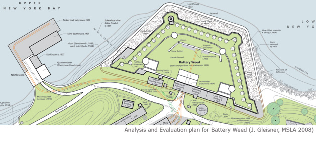
Redoubt and Prospect: Changing Views of a New York City Headland; A Cultural Landscape
Report for Battery Weed
Jean B. Gleisner, MSLA, 2008
This thesis addresses the historic landscape of the Battery Weed headland, a part of Fort Wadsworth on Staten Island, New York. Research was funded by the National Park Service to support its management of the cultural landscape in anticipation of planned improvements.
The 47-acre headland gained significance in its military use defending the entrance to New York Harbor between 1847 and 1945. The site was critical to harbor defenses and navigation, and attracted many visitors because of its panoramic views. Throughout its history, Battery Weed and its surrounding headland were adapted in response to changes in America’s harbor defenses. After World War II, the headland was largely abandoned and overshadowed by the Verrazano-Narrows Bridge completed in 1964. The site was transferred along with the rest of Fort Wadsworth to the Department of the Interior in 1994 as part of the Staten Island Unit of Gateway National Recreation Area. Since this time, the park has restored the abandoned fort, but has had little documentation necessary for management of the adjoining landscape that includes remnants of post-Civil War batteries and an early twentieth-century mining system.
The thesis documents the physical history the landscape in the context of its intertwined military and recreational uses. This research formed the basis for defining the landscape’s historic character and identifying the landscape features worthy of preservation. From this analysis and evaluation, the thesis defines a treatment approach to preserve and enhance the historic character of the landscape in the context of contemporary park uses and environmental constraints. Treatment recommendations in the thesis included clearing of vegetation to reestablish views and open spatial character, and interpretation and stabilization of remnant military structures.
This thesis is also available at SUNY ESF’s Moon Library – Thesis Call Number G585
The project was finalized by the Department of Landscape Architecture into a published National Park Service Cultural Landscape Report.
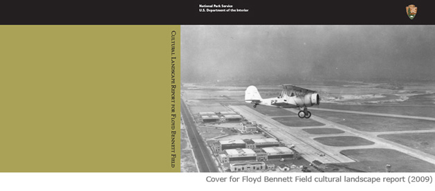
Balancing Past and Present: The Cultural Landscape of Floyd Bennett Field: Site History,
Existing Conditions, and Analysis & Evaluation
Sarah K. Cody, MSLA, 2007
This thesis examines the cultural landscape of Floyd Bennett Field, a former airport and military base in Brooklyn, New York. Research was funded by the National Park Service to support its management of the cultural landscape.
The 1450-acre Floyd Bennett Field site is significant as the first municipal airport in New York City from 1931 to 1941, and then as Naval Air Station New York until 1972. Due to its remote location, Floyd Bennett Field was never a commercial success, but proved popular for aviators and the military. As demand for naval air facilities increased with the approach of World War II, the city sold the airport to the Navy in 1941. During World War II, Floyd Bennett Field was one of the Navy’s most important air stations. After the war, the Navy gradually closed its operations at Floyd Bennett Field until it was decommissioned and transferred to the Department of the Interior in 1971.Since its acquisition, the park has struggled with management of the extensive infrastructure at the site.
The thesis documents the physical history of the landscape from a tidal estuary and industrial community, to a municipal airport and naval air station, and finally a public park within Gateway National Recreation Area. Based on this documentation and National Register criteria, the thesis inventories and evaluates landscape features to determine how each contributes to the historic character of the landscape. The thesis finds that most of the site retains its historic character, but that sections do not due to loss of buildings and open spatial character.
This thesis is available at SUNY ESF’s Moon Library – Thesis Call Number C621
The project was finalized by the Department of Landscape Architecture into a published National Park Service Cultural Landscape Report (see Published Reports)
The Historic Designed Landscapes of Fletcher Steele in Rochester, New York: An Intensive
Level Survey
Christina Jean Selvek, MSLA, 2004
This thesis explores seventy-five properties designed by Fletcher Steele (1885 – 1971) in the Rochester area. Steele maintained offices in Boston from 1915 to 1962, and in Rochester from 1962 to 1971. The thesis provides a history of Steele’s work on residential gardens, identifies his design characteristics, inventories the seventy-five gardens, and provides recommendations for preservation. For three of the surveyed gardens, the thesis also provides treatment recommendations for enhancing historic character based on evaluation of the existing landscape with Steele’s original design intent.
Fletcher Steele’s works are representative examples of a period of landscape architecture that was materially and stylistically experimental. Schooled in the traditional Beaux Arts fashion at Harvard University and trained by Warren H. Manning in the picturesque style, Steele’s own innovative design approach would eventually bridge the gap between classical design principles and modernist functionalism. Throughout his professional career, Steele created more than five hundred landscape designs primarily for single-family residential properties.
This thesis is also available at SUNY ESF’s Moon Library – Thesis Call Number S43912
Cultural Landscape Report Fort Ontario State Historic Site, Volume One: Site History,
Volume Two: Existing Conditions, Analysis and Evaluation
Robert J. Hetzler, MSLA, 2003
This thesis addresses the historic landscape of Fort Ontario, a 40-acre state historic site in the City of Oswego, New York overlooking the confluence of the Oswego River and Lake Ontario. Research was funded by the New York State Office of Parks, Recreation and Historic Preservation to support its management of the cultural landscape.
During the seventeenth and eighteenth centuries, the importance of the fur industry led to numerous conflicts between the English and the French for control over the Mohawk-Oneida-Oswego river system. The confluence of the Oswego River and Lake Ontario was a key entry point to this river system and the battle for control of this location resulted in the construction of a fort there by the British in 1756. The existing pentagonal stone fort was constructed by the British in 1782, and turned over to the United States in 1796. Through 1946, the site was an active federal military reservation used as a defense installation, a training base, and housing for Jewish refugees from the Holocaust during World War II. In 1946, the fort was turned over to the State of New York and in 1949, a portion was designated as Fort Ontario State Historic Site.
The thesis consists of volume 1 (site history) and volume 2 (existing conditions and evaluation). It documents the physical history of the site, and identifies the landscape features, characteristics, values, and associations that make the site historically significant. The thesis recommends that the period of significance encompass the period from 1755 to 1954 to include the entire military history of the site as reflected in the existing landscape, as well as early state improvements in adaptation to a historic site.
This thesis is available at SUNY ESF’s Moon Library – Thesis Call Number H485
Cultural Landscape Report for the Home of Franklin D. Roosevelt National Historic
Site
Kristin Baker, MLA, 1999
This thesis addresses the cultural landscape of Springwood, the core of the Roosevelt family estate in Hyde Park, New York that was the home of Franklin D. Roosevelt (FDR), 32nd President of the United States. The research was funded by the National Park Service to provide a foundation for future preservation strategies and management decisions related to this significant cultural landscape.
Springwood was the home of the Roosevelt family for almost 80 years, starting in 1867 when James Roosevelt purchased the estate, and lasting until 1945 when FDR died and the site was turned over to the National Park Service. The house served as campaign headquarters when FDR entered politics in 1910. At Hyde Park, FDR explored many of the land stewardship ideals he championed as governor and president, including reforestation and historic preservation. Following construction of his presidential library on a part of the landscape, FDR gave Springwood to the United States in 1943, and it opened to the public as a National Historic Site in 1946.
The thesis documents the physical history of the landscape, inventories its existing landscape characteristics and features, and evaluates which of those features contribute to the historic character of the landscape. Despite some changes to the property, the landscape remains remarkably intact since FDR’s death in 1945 and the historic character of a working farm and private residence is still evident.
This thesis is also available at SUNY ESF’s Moon Library – Thesis Call Number B334
Cultural Landscape Report for Herkimer Home State Historic Site
Barbara Henderson, MLA, 1999
This thesis documented the cultural landscape of Herkimer Home, a state historic site in the Mohawk Valley town of Little Falls, New York. The research was funded by the state Office of Parks, Recreation and Historic Preservation to inform management of the landscape.
Herkimer Home was originally deeded to Nicholas Herkimer in 1752, and subsequently belonged to other members of the Herkimer family until 1814. Nicholas Herkimer and his family played a prominent role in the eighteenth century development of the Mohawk River as a major transportation corridor to link eastern New York communities with western outposts. Herkimer was also a well-known military figure due to his ability to rally 800 men and boys during a British attack during the American Revolution in 1777 in the Mohawk Valley frontier. The Iroquois and British-allied Loyalists wounded Herkimer in the leg during an ambush. He was taken back to his home in Little Falls where his leg was amputated. He died ten days later from the injury sustained at the Battle of Oriskany and was regarded as a hero and martyr to the cause of American freedom. In 1913, the State of New York officially acquired 149.37-acre site from then owner Gertrude Bidleman Garlock.
The thesis includes a site history, existing conditions inventory, and analysis of significance. Since its acquisition by the state, the focus of management has been on the house. Research for the thesis supported expansion of the National Register documentation to include all the significant historic character-defining landscape features. These findings provide a basis for sound management and preservation of the historic rural landscape.
This thesis is also available at SUNY ESF’s Moon Library – Thesis Call Number H442
Cultural Landscape Report for Lorenzo State Historic Site
William Paul Fritz, MLA, 1997
This thesis addressed the cultural landscape of Lorenzo State Historic Site in Cazenovia, New York, home of the Lincklaen and Ledyard family for 160 years. The research was supported by the state Office of Parks, Recreation and Historic Preservation and the Friends of Lorenzo to inform management of the landscape.
An 87-acre property overlooking Cazenovia Lake, Lorenzo is significant for its association with John Lincklaen, a Holland Land Company agent who founded the village of Cazenovia in 1793, and as an outstanding example of Federal-period architecture. Lincklaen Ledyard, a naturalist by avocation, inherited the property in 1847 from Helen L. Lincklaen. Although he was sympathetic to romantic landscape ideas, Ledyard was also sensitive to the formal organization established by John Lincklaen, ultimately combining a range of design philosophies. The size of the property decreased over time; however, John Lincklaen and his heirs, the Fairchild and Remington families, occupied and preserved the estate for 160 years. In 1968, New York State acquired the Lorenzo property as an historic site.
This thesis, which was the recipient of a New York State Historic Preservation Award in 1998, documents the landscape’s physical history, inventories its existing conditions, and evaluates its characteristics and features. Based on this evaluation, the thesis provides preliminary treatment recommendations for preservation and enhancement of the historic landscape.
This thesis is also available at SUNY ESF’s Moon Library – Thesis Call Number F7745
Cultural Landscape Report for Sagamore Hill National Historic Site
Regina M Bellavia, MLA, 1995
This thesis examined the cultural landscape of Sagamore Hill National Historic Site in Oyster Bay, Long Island, New York. The site is significant as the country home of Theodore Roosevelt, 26th President of the United States. The research was funded by the National Park Service to inform its management of the site.
The site, which served as the Summer White House from 1901 through 1909, was Theodore Roosevelt’s family home, where he conducted official presidential business, where he worked and played, and ultimately where he died. Throughout his tenure, the property was a working farm with a garden, pastures, and agricultural fields. Although eventually surrounded by palatial estates of Long Island’s Gold Coast Era, Sagamore Hill remained a modest country home, an embodiment of the President’s ideals of home, family, and love of nature. The site became a National Historic Site in 1962 and was donated by the Theodore Roosevelt Association to the Federal Government in 1963.
This thesis documents the landscape’s historic development, inventories its existing condition, and evaluates its characteristics and features that define the character that existed during Theodore Roosevelt’s lifetime through its initial stewardship as a historic site. The thesis finds that Sagamore Hill’s rural landscape lost some of its historic character during public stewardship and through long-time focus on building management. Among many changes, this led to growth of woods on formerly open fields that altered historic spatial character and views.
This thesis is available at SUNY ESF’s Moon Library – Thesis Call Number B46126. It was finalized into a published National Park Service Cultural Landscape Report.
Cultural Landscape Report: Oakwood Cemetery
Karen E. Day, MLA, 1994
This thesis addresses the cultural landscape of Oakwood Cemetery, a private 82-acre rural cemetery in Syracuse, New York, designed by landscape architect Howard Daniels in 1859.
In 1859, a committee of Syracuse residents decide to locate a rural cemetery amid rolling hills and farms just south of the city proper. The cemetery is significant as an example of a rural cemetery, a burial place characterized by spacious landscaped grounds and romantic commemorative monuments established in a rural setting. Beginning with the development of Mount Auburn Cemetery in Cambridge, Massachusetts in 1831, rural cemeteries were the first American landscapes to treat nature as contained and manipulated settings that provided contrast to nearby cities. Oakwood is an intact example of this style. In 1991, the City of Syracuse designated Oakwood Cemetery a local protected site, and it was listed in the National Register of Historic Places.
The thesis provides the site with long-term planning and management of the Oakwood Cemetery landscape. Treatment recommendations are based on the research and analysis of the cemetery landscape and the three prototype areas developed for the purposes of this thesis: the entry area, the inner core, and the five privately owned lots.
This report is available at SUNY ESF’s Moon Library – Thesis Call Number D384
Cultural Landscape Report for Martin Van Buren National Historic Site
David l. Uschold, MSLA, 1993
This thesis addressed the cultural landscape of Lindenwald, the home and farm of Martin Van Buren, eighth President of the United States, near the village of Kinderhook in New York’s Hudson Valley. Research was funded by the National Park Service to inform its management of the cultural landscape.
Martin Van Buren established his home as a 221-acre experimental and working farm and managed it for twenty-three years, beginning in 1839. His residency on the property began at the completion of his presidential term in 1841, and lasted until his death in 1862. In 1961, Lindenwald was declared a National Historic Landmark. The National Park Foundation purchased the property in 1975 and it was transferred to the National Park Service.
The thesis documented the physical history of the landscape, inventoried its existing conditions, and evaluated its characteristics and features to identify the historic character that existed during President Van Buren’s lifetime. The research provided the basis for completion of a landscape treatment plan (CLR Part II) that was developed by the Olmsted Center in 1996.
This thesis is available at SUNY ESF’s Moon Library – Thesis Call Number – U854
The project was finalized into a published National Park Service Cultural Landscape Report.
Cultural Landscape Report, Laboratory Unit, Edison National Historic Site
Eric F. Joseph, MLA, 1992
This thesis examined the landscape of the Laboratory Unit at Edison National Historic Site, a 5.78-acre site in West Orange, New Jersey. It was the location of Thomas Alva Edison’s laboratory from 1887 to 1931, the year of his death. The research was supported by the National Park Service to inform planned preservation of the cultural landscape.
Edison became famous for developing the first incandescent light bulb. Although he already had facilities in Menlo Park and New York City, he wanted a separate complex that combined inventive research and industrial manufacturing, resulting in the establishment of the Edison Laboratories in 1887. For the next 44 years Edison, invented and experimented on projects including the development and improvements on electric lighting, photography, motion pictures, and battery power. The Laboratories became the hub of activity at what became known as the West Orange Plant. In 1962, Edison’s home, Glenmont, was donated to the National Park Service and together the two units, Laboratory unit and Glenmont comprise the Edison National Historic Site. The period of significance for the Laboratory Unit of Edison National Historic Site is 1887-1931. The period encompasses Edison’s tenure at the site from its construction in 1887 until his death in 1931.
This thesis consists of a site history in five chapters, and a final chapter containing a site analysis. The thesis recommends that the cultural landscape be considered part of the site’s significance. It also provides a variety of treatment recommendations for the proposed rehabilitation of the site to enhance its historic character during the period of significance.
This thesis is available at SUNY ESF’s Moon Library – Thesis Call Number J6916
Historic Landscape Report for Meadow Croft, Former Summer Home of John Ellis Roosevelt
Richard C. Collins, MLA, 1991
This thesis addressed the cultural landscape of Meadow Croft, the former country home of John Ellis Roosevelt, a cousin of President Theodore Roosevelt, in Sayville, Long Island, New York. This study followed completion in 1986 of a Historic Structures Report for the Meadow Croft house by Suffolk County Department of Parks, Division of Historic Services.
Meadow Croft had the unique attribute of being one of the three contiguous estates that compromised the Roosevelt Family Compound; the other two estates were owned by John’s brother, Robert B. Roosevelt Jr., and their father, Robert B. Roosevelt. Robert B. Roosevelt, an uncle of President Theodore Roosevelt, was the first Roosevelt to establish a country place on the south shore of Long Island, while most of his relatives chose to reside in Oyster Bay on the Island’s north shore. Meadow Croft is one of the finest examples of a country home from the turn-of the-century resort era on the south shore of Long Island. The site was laid out in the picturesque style containing an ornamental pleasure garden and farm. It is a vivid reminder of a transitional episode in the development of Long Island’s south shore from small agricultural villages to summer estates and resort communities of the wealthy.
This thesis consists of three sections, site history, evaluation and analysis, and treatment. The final section of this thesis formulates a plan consisting of guidelines and recommendations that to restore the landscape, including the pleasure grounds and the small active farm area that contribute to the significance of the landscape. The surrounding woods and marshes are protected as part of the Suffolk County San Souci Lakes Nature Preserve. The county has preserved 64.8 acres of the original estate property.
This thesis is available at SUNY ESF’s Moon Library – Thesis Call Number C6383
Preservation of a Designed Historic Landscape: Thornden Park Syracuse, New York
Constance E. Zipperer, MLA, 1991
This thesis addressed the cultural landscape of Thornden Park, a city park in Syracuse, New York, that is significant as a part of the American Urban Park Movement.
Major Alexander Davis, a retired officer from the Civil War, purchased 76 acres of land in the southeast section of the city of Syracuse in 1873. For the next twenty years, Major Davis fashioned Thornden into a traditional English estate. A gate lodge marked the entry to the estate, while drives, lined with plantings, wound their way past the country house, greenhouses, barn, and stables. By 1900, the family moved to England and the gardener, David Campbell managed the property. Campbell later acquired a ten-year lease from the family while he served as Superintendent of the Syracuse City Parks. By 1912, real estate developers wanted to purchase the Thornden estate to build houses. A committee from the Chamber of Commerce opposed this and proposed that the estate become a city park. In 1921, the city of Syracuse purchased the estate from the Davis family for a park. The new Thornden Park combined pleasure ground design of the estate with the growing enthusiasm for active recreation in American parks typical of the Reform Park era. Thornden Park is also representative of a park landscape that possesses characteristics features of planning and designs within the Urban Park Movement. The park was awarded local designation as a protected site in 1989 by the City of Syracuse Planning Commission and was listed in the National Register of Historic Places.
This thesis will serve the City of Syracuse and its Landmark Preservation Board as preservation guidelines for the future planning and treatment of a valuable historic community park.
This thesis is available at SUNY ESF’s Moon Library – Thesis Call Number Z642
The Physical Treatment of Cultural and Historic Resources: Guideline for Rehabilitating
Designed Historic Landscapes
Christine Capella Peters, MSLA, 1990
This thesis addresses the application of preservation guidelines in the Secretary of the Interior’s Standards for Archeology and Historic Preservation: Standards for Historic Preservation Projects and accompanying Guidelines, to cultural landscapes. The thesis addresses broad based philosophies, the most detailed recommendations regarding the rehabilitation of designed historic landscapes.
Federal, state and local government agencies charged with the review of proposed public and private projects have the authority and responsibility to evaluate the potential impact of a project on cultural and historic resources. Professional staff involved in these reviews utilizes the Secretary of the Interior’s Standards when assessing potential impact on cultural and historic resources. This document, however, has limited application to non-architectural landscape resources.
In attempting to apply subsections of the Secretary of the Interior’s Standards to activities involving landscape resources, it becomes evident that a bias toward architecture underlies the entire document. This thesis is a response to the inconsistent interpretation for these standards as applied to historic landscape resources.
This thesis is available at SUNY ESF’s Moon Library – Thesis Call Number P472
Master of Landscape Architecture Capstones
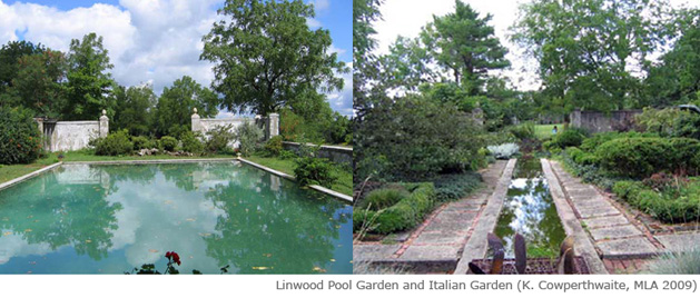
Two Gardens and a View: Revealing the History and the Future of an American Country
Place in Western New York, Linwood
Karen E. Cowperthwaite, MLA, 2008
This capstone addressed the cultural landscape of Linwood, a country place in the Western New York town of York that was the summer home of William H. Gratwick, II and his family. The private owners of Linwood are presently developing plans for the rehabilitation of the Linwood landscape as a historic site with limited public access.
William H. Gratwick, a Harvard trained architect and son of a prominent lumber business owner, purchased three plots of farmland, totaling 350-acres in 1899. His son, William H. Gratwick III, also went to Harvard for an A.S. in History in 1926 and then a Master of Landscape Architecture in 1929. Gratwick III is best known for his experiments with boxwood crosses and tree peony hybridization. In the 1960s, Gratwick began the Tree Peony Festival to show and sell the plants. His daughter, Lee Gratwick, owns the property and opens the garden in late spring when the tree peonies are blooming. A private, family home for more than one hundred years, its buildings and gardens have deteriorated due to a lack of funds, yet the landscape remains an outstanding example of early twentieth-century garden design. Linwood was listed in the National Register of Historic Places in 1997.
The capstone report provides Linwood’s owners with treatment recommendations for the restoration of the Italian Garden and Pool Garden. The report also acknowledges that the larger Linwood cultural landscape can support proposed use of the site for education in the arts, horticulture, gardening, landscape architecture, and historic preservation.
Rehabilitation Treatment for the Matilda Joslyn Gage Property
Michael Commisso, MLA, 2004
This capstone addressed the cultural landscape of the Matilda Joslyn Gage Property in Fayetteville, New York. The site is significant as an example of Greek Revival architecture and for its association with Matilda Joslyn Gage, an abolition and women’s rights advocate during the nineteenth century.
In 1854, dry-goods merchant Henry Gage moved with his wife, Matilda Joslyn, and their three children to the growing village of Fayetteville. Beside the house, the small village property included a barn, icehouse, woodshed, apiary, orchard, ornamental garden, vegetable garden, and a variety of flowering shrubs and trees. The Gage home was used as a station on the Underground Railroad and today it is on the New York State Underground Railroad Heritage Trail. After the Civil War, daughter Matilda Joslyn Gage was, along with Elizabeth Cady Stanton and Susan B. Anthony, a founding member of the National Woman Suffrage Association. She held meetings in her home when the leadership of the New York Woman Suffrage Association gained the right for women to vote and run in school elections in 1880. The property changed ownership following the death of Matilda Joslyn Gage in 1898. While the house historically was a single-family residence, it changed to a multiple-family unit at an unknown date. The Matilda Joslyn Gage Foundation purchased the property in 2001 and currently uses the building for museum and office space.
This thesis is intended to inform the Matilda Joslyn Gage Foundation’s plan to rehabilitate the landscape based on interpretations from the photographs taken in 1887 by L. Frank Baum, son-in-law of Gage and author of the Wizard of Oz, and from the Gage family letters. The treatment plan balances new and future use of the Gage property while recapturing the historic character that existed during the period of significance.
Mauchline: Rehabilitation Treatment Plan for the Historic Designed Landscape at Mauchline,
Wilmington, Delaware
Timothy William Layton, MLA, 2002
This capstone addressed the historic designed landscape at Mauchline, an early twentieth-century residence in the city of Wilmington, Delaware.
Landscape architect Elizabeth Bootes Clark and architects, Wilson Eyre and Mcllvaine designed the grounds and house at Mauchline between 1916-17 for Frank Gifford Tallman, then Vice President of the DuPont Company. The property remained with the Tallman family descendents until 1971, when it was sold to St. Anthony’s of Padua Roman Catholic Church to use as a convent. The spatial organization, topography, circulation, and small-scale features that comprise the landscape have retained a high degree of integrity.
This capstone will provide the property owners with a schematic treatment plan for the rehabilitation of the landscape. To facilitate design decisions for the treatment plan, period plans were produced representing the landscape at various points. These plans were developed from the existing conditions plan and a substantial collection of historic photographs from 1918 to 1973.
Conserving a Landscape Palimpsest: Interpretive Interventions at Oriskany Battlefield
State Historic Site
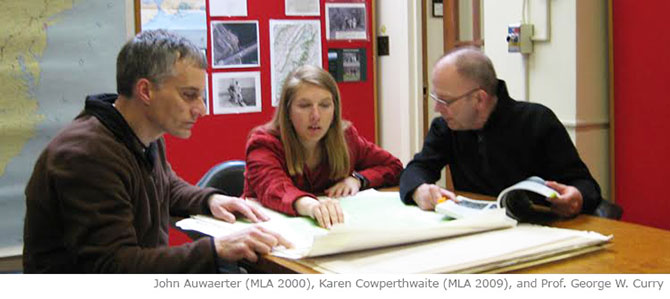
John E. Auwaerter, MLA, 2000
This capstone project explores treatment issues in cultural landscape conservation at the Oriskany Battlefield State Historic Site, a National Historic Landmark in Whitestown (Mohawk Valley), New York. This capstone was based on a Cultural Landscape Report Part I (site history, existing conditions, analysis and evaluation) developed by the author (see “Independent Research and Internships”).
The Oriskany Battlefield was designated a National Historic Landmark in 1963 due to its significance as the location of a decisive Revolutionary War battle and as a late 19th and early 20th century memorial to the battle. The Oriskany Battlefield has two periods of historic significance: the Battle of Oriskany (August 6, 1777) which took place within a landscape of old-growth forest and transportation corridors: and the period of sustained commemoration (1877 to c. 1955), which took place within a landscape of agriculture, re-emergent forest, and transportation corridors.
Intended as part of an eventual treatment plan (CLR Part II), this capstone report is intended to guide the site in enhancing the historic character and interpretive value of the battlefield through intervention into three landscape characteristics: spatial organization, views and vistas, and circulation. The treatment plan recommends reestablishing part of the historic spatial organization of the forest context (battle period) and open space and views of the agricultural context (commemorative period), and links these landscapes through improved pedestrian access along new paths and historic transportation corridors. Management of the landscape has been limited by lack of documentation and layering of two distinct periods of significance. The proposed treatment reveals this landscape palimpsest while preserving landscape characteristics from both periods of significance in a physically distinct yet related manner.
Summer Field School
The Department of Landscape Architecture and the National Park Service Olmsted Center for Landscape Preservation offer six-week summer field schools to undergraduate and graduate students to learn issues of park management, with a focus on the methods and practices of cultural landscape preservation. The field school, usually held on a biannual basis, is a six or three credit course (LSA 496/696). Students receive free housing at the parks and a stipend to cover transportation and meals.
Students learn methods of park management and cultural landscape preservation, including inventory, historical research and analysis, conditions assessment, mapping, and photography. Students also gain practical experience working on actual preservation planning projects for the National Park Service involving research and fieldwork for the preparation of Cultural Landscape Inventories. During the course of the field school, cultural landscape experts teach a range of topics related to the history, management, and use of park landscapes, as well as broader contexts concerning historic preservation, natural resources, and park design. While focused on historic preservation planning, the field schools offer skills applicable to a wide range of practice related to landscape architecture and environmental stewardship.
Hiking Trails Mapping
Acadia National Park, Maine
Student Participants:
Bill Elliot, MLA SUNY ESF
Sarah Hoagland, BLA SUNY ESF
Jessey Horvat, MLA SUNY ESF
Sara Reinstein, MLA SUNY ESF
Vincent Ryan, BLA SUNY ESF
Pamella Selby, BLA SUNY ESF
Nicholas Shannon, BLA SUNY ESF
Offered in partnership with the National Park Service Olmsted Center for Landscape Preservation, the National Park Service Field School provided seven students with hands-on experience in park management and cultural landscape preservation.
The 2015 summer field school, the fourth offered through SUNY ESF, was held at Acadia National Park, located on the Atlantic coastline of Maine approximately six hours north of Boston. The course introduced students to the methods, processes, and techniques of cultural landscape preservation and park management, taught through a combination of field work and classroom learning. Lectures and discussion, led by SUNY ESF and NPS staff, addressed natural and cultural resource management, historic preservation standards and guidelines, mapping techniques including GIS, oral history, trail maintenance and construction, and park operations. Students applied this learning to field work involving documentation of Acadia’s historic trails, which date back to the 19th century.
Carriage Road System
Acadia National Park, Maine
Student Participants:
Benjamin Boisclair, BLA SUNY ESF
Sara Bonacquist, BLA SUNY ESF
Charlotte Evanofski, BLA SUNY ESF
Margaret Johnson, MLA SUNY ESF
Catherine Ponte, MLA SUNY ESF
Tutku Ak, Ph.D., GPES, SUNY ESF
Offered in partnership with the National Park Service Olmsted Center for Landscape Preservation, the National Park Service Field School provided six students with hands-on experience in park management and cultural landscape preservation. The 2012 summer field school, the third offered through SUNY ESF, was held at Acadia National Park, located on the Atlantic coastline of Maine approximately six hours north of Boston. During the six weeks of the field school, students participated in lectures and discussions with National Park Service and SUNY ESF staff, and collected field data on thirty-two miles of the historic Acadia carriage road system. Students completed field inventory of landscape characteristics and features on thirty-two miles of the carriage road system. This data will provided the basis of a Cultural Landscape Inventory (CLI), which is the National Park's Service's database of its historically significant landscapes. SUNY ESF will be completing maps of the carriage road system for the CLI, and the NPS Olmsted Center will complete the final CLI.
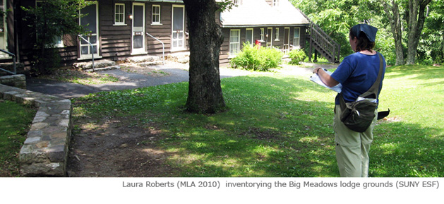
Five Component Landscapes
Shenandoah National Park, Virginia
Student Participants:
John Quattrocchi, BLA SUNY ESF
Laura Roberts, MLA SUNY ESF
Mark Simon, BLA SUNY ESF
Addy Smith-Reiman, MLA Cornell University
David Washburn, Graduate Assistant, MLA SUNY ESF
During the 2008 field school, five students inventoried historic landscapes at five areas of the park: Big Meadows, Park Headquarters, Rapidan Camp (former camp of President Hoover), Dickey Ridge, and South River Picnic Grounds. Most of the landscapes were initially developed by the Civilian Conservation Corps during the 1930s. Students focused on inventorying existing landscape characteristics and features, and on historical research in park archives. Graduate assistant David Washburn developed graphic plans for the five landscapes during the academic year following the field school. The research, inventory, and mapping were incorporated into final CLI inventories completed by the Olmsted Center for Landscape Preservation.
Appalachian Trail, Shenandoah National Park, Virginia
Student Participants:
Karen Cowperthwaite, Graduate Assistant, MLA SUNY ESF
Jeanie Gleisner, MLA SUNY ESF
Gregory Losapio, BLA SUNY ESF
Avery Myers, BLA SUNY ESF
Molly Oliver, BLA SUNY ESF
Daniel Stazzone, BLA SUNY ESF
During the summer 2006 field school, six students inventoried the cultural landscape of the Appalachian National Scenic Trail through Shenandoah National Park. The trail, built in the late 1920s and improved by the Civilian Conservation Corps in the 1930s, forms the spine of Shenandoah along with the Skyline Drive. Using GPS, the students inventoried all cultural features along the entire 103 miles of the trail through Shenandoah, including trail markers, stone walls, shelters, wolf trees, forest plantations, and views. Students also researched the history of the trail in park and trail archives. During the academic year following the summer school, Graduate Assistant Karen Cowperthwaite worked with ESF Ph.D. student Mehmet Yavuz to create interactive GIS maps of the trail, the first time that the park service had created such maps for a CLI. The Olmsted Center for Landscape Preservation finalized the research and mapping into Cultural Landscape Inventories for three management zones of the Appalachian Trail within Shenandoah: North District, Central District, and South District.
Thematic Studios
LSA 470/670, Treatment Concepts for Chancellorsville Battlefield
Spring 2015
Student Participants:
Bill Elliot, MLA
Chris Kraus, BLA
Esvin Secaida, BLA
Greg Ernst, BLA
Lauren Ziska, BLA
Matt Leach, BLA
Mike Sheldon, BLA
Olivia Liu, BLA
Victoria Kam, BLA
In the spring of 2015, ESF Professor Margaret Bryant led a thematic studio that investigated planning and design issues at the Civil War-era Chancellorsville Battlefield, part of Fredericksburg and Spotsylvania National Military Park in Virginia. The studio followed completion of a Cultural Landscape Report Part I (site history, existing conditions, analysis & evaluation) through the CCLP. The work of the studio provided a conceptual basis for development of a full treatment plan (CLR Part II) currently being developed through the center’s partnership with the Olmsted Center for Landscape Preservation.
The students worked in collaboration with CCLP and NPS staff to identify issues and conceptual design and planning solutions. At over 1,600 acres on multiple parcels, the once remote and rural Chancellorsville landscape is being impacted by suburban development in the fast-growing region one hour south of Washington D.C The crossroads character of Chancellorsville, in all its various dimensions, guided the studio’s development of treatment options for the park.
This studio provided landscape architecture students with opportunities to assemble and evaluate data that reflects the historical development and character-defining features of Chancellorsville Battlefield's cultural landscapes: the natural physiography, patterns of forest and field, the relationship of roads and structures, and the development of post-war accretions, including commemorative landscapes. The studio also gave the students exposure to the many management challenges facing national parks, as well as an opportunity to explore what it means to preserve a cultural landscape.
LSA 470/670, Treatment Concepts for Eleanor Roosevelt National Historic Site
Spring 2008
Student Participants:
Emily Clark-Waterson, BLA
Alex Kuznirk, BLA
Jim Pagano, BLA
Douglas Richard, BLA
Byrne Riley, MLA
This studio provided landscape architecture students with opportunities to explore issues of historic landscape design and planning at Eleanor Roosevelt National Historic Site in Hyde Park, New York. The work of the studio provided a conceptual basis for development of a full treatment plan (Cultural Landscape Report Part II) completed in 2013 under the department’s partnership with the Olmsted Center for Landscape Preservation (see Published Reports section).
As an initial step in developing treatment concepts, students updated existing conditions plans and visited the 179-acre site to gather field data. The treatment plan was based on a Cultural Landscape Report prepared by the Olmsted Center for Landscape Preservation in 2005. Students identified a range of treatment issues, from loss of ornamental plantings and open fields, to incompatible parking areas and lighting. Proposed concepts included rewatering the swimming pool and reconstructing a dock, rehabilitating gardens and perpetuating agricultural uses, building trails, and redesigning the parking area, lights, and signs.
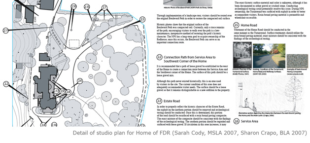
LSA 470/670, Treatment Concepts for the Home of Franklin D. Roosevelt National Historic
Site
Spring 2006
Student Participants:
Connie Bankus, BLA
Sarah Cody, MLA
Karen Cowperthwaite, MLA
Sharon Crapo, BLA
Jeanie Gleisner, MLA
Allen Guenthner, BLA
Samuel Jimenez, BLA
Lynn Jordan, BLA
Aaron Pastore, BLA
This studio provided landscape architecture students with opportunities to explore
issues of historic landscape design and planning at the Home of Franklin D. Roosevelt
National Historic site in Hyde Park, New York. The work of the studio provided a conceptual
basis for development of a full treatment plan (Cultural Landscape Report Part II)
completed in 2009 under the department’s partnership with the Olmsted Center for Landscape
Preservation (see “Published Reports”).
Students developed conceptual treatment plans for Springwood, the core of the historic
site containing the main Roosevelt house, gardens, and gravesite. Students also addressed
the landscape of the adjoining Franklin D. Roosevelt Presidential Library and Museum,
and the entrance to the site through the adjoining estate, Bellefield. Treatment was
based on the findings of a cultural landscape report for Springwood developed by MSLA
student Kristin Baker (see Master’s Theses). Students addressed a broad range of treatment
issues, from loss of gardens and views, addition of inappropriate paving materials
and park furnishings, to loss of forest plantations. Treatment concepts included use
of alternative road pavements that better characterized the historic gravel and earthen
surfaces, reestablishment of Hudson River views, replacement of lost plantings, and
redesign of contemporary visitor circulation through the library property.
Independent Research and Internships
The following projects are independent research and internship projects funded through the department’s partnerships with the National Park Service and State Office of Parks, Recreation and Historic Preservation. These partnerships have also provided numerous opportunities over the years for students to assist with a variety research projects for credit and pay (not listed below).
Cathy Ponte, 2013 (MLA, 2015)
Cathy is undertaking research and writing to prepare a site history of the Chancellorsville
Battlefield as part of a summer 2013 internship and fall 2013 graduate assistantship.
Her work is supporting a Cultural Landscape Report being prepared for the 1,600-acre
battlefield in central Virginia.
Nathan Powers, 2012-13 (MLA 2014)
Nathan is developing existing conditions maps using ArcGIS and Adobe Illustrator as
an hourly graduate assistant and summer 2013 intern. His work is supporting a Cultural
Landscape Report being prepared for the 1,600-acre battlefield in central Virginia.
Tutku, the graduate assistant for the summer 2012 National Park Service Field School at Acadia National Park, prepared illustrated GIS maps for the carriage road system based on the data collected by the field school students. Tutku was supported as a 10-hour per week Research Project Assistant for the fall and spring of 2012-13. She completed the mapping in May 2013.
Ella continued work on mapping begun by Laura Roberts at Forts Baker, Barry, and Cronkhite on the Marin Headlands as part of an hourly graduate assistantship.
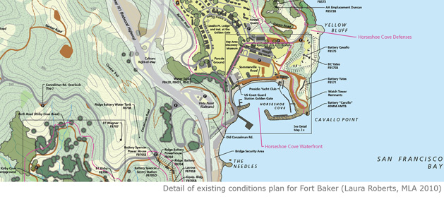
Laura Roberts, 2009-2010 (MLA 2010)
This internship, funded by the National Park Service in part through the Student Conservation Association, support preparation of a Cultural Landscape Report for the Forts Baker, Barry, and Cronkhite Historic District on the Marin Headlands in Marin County, California (San Francisco). The internship focused on the development of existing conditions plans and inventory information. The Cultural Landscape Report, being prepared through the department’s partnership with the National Park Service, is anticipated for completion in 2013.
Karen Cowperthwaite, 2009 (MLA 2009)
This post-graduate internship funded by the National Park Service supported preparation of a Cultural Landscape Report for the small 4.5-acre national memorial in downtown Providence, Rhode Island. The internship provided experience in historical research and development of graphic plans.
Karen Cowperthwaite, 2008-2009 (MLA 2009)
Mehmet Yavuz, 2008-09 (PhD 2009)
This internship, funded by the National Park Service, supported preparation of a prototype Cultural Landscape Inventory for a section of the Appalachian Trail that crossed multiple ownership boundaries. The internship focused on mapping inventoried cultural landscape features along the portion of the trail in Massachusetts using linear GIS mapping techniques.
Paul M. Harris, Jr., 2007-2010 (MSLA, 2010)
This internship and independent research, funded in part by the National Park Service through the Student Conservation Association, supported preparation of a Cultural Landscape Report for Ellwood, a historic plantation within the Wilderness Battlefield unit of the national military park. The internship provided experience in inventorying existing landscape conditions, historical research, methods of analysis and evaluation, and development of graphic plans. The Cultural Landscape Report was finalized into a published National Park Service report in 2010.
Christina Selvek, 2005 (MLA 2004)
This post-graduate internship, funded by the National Park Service through the Student Conservation Association, involved the preparation of site history, existing conditions, and analysis and evaluation for Fort Tilden, an early twentieth-century Army reservation in Queens, New York. The internship included writing, research, and development of illustrated plans documented historic and existing conditions. The Cultural Landscape Report, being prepared through the department’s partnership with the National Park Service, was completed in 2013 following resolution of National Register issues in 2009 (see Published Reports section).
Rob Mooney, 2001 (MLA 2001)
This was a funded post-graduate summer internship to support the preparation of preliminary preservation guidelines for the Mansion Grounds, the domestic component of Marsh-Billings-Rockefeller National Historical Park in Woodstock, Vermont. The internship involved gathering existing conditions data on the landscape through site visits, and preparing recommendations for improving hemlock hedges, gardens, and built features that had condition issues. The research was finalized into a report entitled “Stabilization and Maintenance Guidelines for the Mansion Grounds” completed by the National Park Service Olmsted Center for Landscape Preservation in fall 2001.
Cultural Landscape Report for Oriskany Battlefield State Historic Site
John Auwaerter, 1998-2000 (MLA 2000)
This internship was funded by the state Office of Parks, Recreation and Historic Preservation to support its management of Oriskany Battlefield in Whitestown, New York. The research included preparation of site history, existing conditions, and analysis and evaluation sections of a Cultural Landscape Report. The report was completed in November 2000.
Historic Landscape Report, Canfield Park - Denison Park, Corning, New York
Kenneth J. Allen (BLA 1994), George W. Curry
This project was prepared by Kenneth J. Allen under the direction of George W. Curry for the Market Square Restoration Agency, with funding provided throgh the New York State Council on the Arts. The report documented the historic development of Canfield Park, designed by city engeineer Robert H. Canfield in 1905, and Dension Park, designed by landscape architect Harold A. Caparn in 1906. The report also provided a feature-level inventory of the existing landscapes and provided recommendations on their significance.
Cultural Landscape Inventories
The National Park Service’s need to prepare Cultural Landscape Inventories for its historic landscapes has provided numerous funded research projects for graduate students (see also “Summer Field Schools” section). These projects have served as summer, semester, or year-long internships. All of the following research projects were finalized into Cultural Landscape Inventories by the National Park Service Olmsted Center for Landscape. This list does not include work done as part of summer field schools.
National Park Service Cultural Landscapes Inventory
Springfield Armory National Historic Site, Springfield, Mass.
Amy Kinsey, 2002
Cultural Landscapes Inventory, Hunt House
Women’s Rights National Historical Park, Waterloo, New York
Rob Mooney, 2000 (MLA 2001)
Cultural Landscapes Inventory for Fort Stanwix
Rome, New York
John E. Auwaerter, 1999 (MLA, 2000)
Cultural Landscapes Inventory for Fort Nonsense
Morristown National Historic Park, New Jersey
John E. Auwaerter, 1998 (MLA, 2000)
Cultural Landscapes Inventory for the Stanton House
Women’s Rights National Historical Park, Seneca Falls, New York
John E. Auwaerter, 1998 (MLA, 2000)
Cultural Landscape Inventory for the M’Clintock House
Women’s Rights National Historic Park, Seneca Falls, New York
David I. Uschold, 1993 (MLA, 1993)
Cultural Landscape Inventory Initiation
Multiple National Park Sites, 1993
George W. Curry, Aida Khalil, Neil Gagliardi
This project was a field-testing of the nascent Cultural Landscape Inventory methodology carried out in the summer of 1993 under the direction of George W. Curry for the North Atlantic Regional Office of the National Park Service. The project, which served as summer internships for two graduate students, produced preliminary Cultural Landscape Inventory Reports for Saratoga National Historical Park, Fort Stanwix National Monument, Martin Van Buren National Historic Site (NHS), Sagamore Hill NHS, Theodore Roosevelt Inaugural NHS, Edison NHS, Eleanor Roosevelt NHS, Home of Franklin D. Roosevelt NHS, and Women’s Rights National Historical Park. The project provide the National Park Service with valuable information on issues such as scope and level of detail, use of information, boundaries, relationship between CLIs and Cultural Landscape Reports, and level of needed historical documentation.
Published Reports
The following published reports are products of research completed through the Department of Landscape Architecture’s partnership with the National Park Service Olmsted Center for Landscape Preservation. Many of the reports were initiated as student theses, independent research project, thematic studios, and internships.
Cultural Landscape Reports
Cultural Landscape Report for Gettysburg National Cemetery
John Auwaerter, 2017
Christopher Anderson, Catherine Ponte, Nathan Powers and Pamella Selby, Student Assistants
George W. Curry, Project Director
This project, begun in spring 2013 and completed in 2017, provide a comprehensive landscape management plan for Gettysburg National Cemetery, which was established in 1863 as Soldiers’ National Cemetery according to a plan by the landscape gardener and botanist William Saunders. The cemetery was dedicated in 1863, during which President Lincoln gave him famous Gettysburg Address. The cemetery, which was incorporated into the National Cemetery System in 1872 and expanded with an annex in 1968, contains approximately 3,620 interments associated with the Battle of Gettysburg, and approximately 3,770 post-Civil War interments. Research documented the historic and existing conditions of the landscape, identified characteristics and features that contribute to its historic significance, and provided recommendations for the rehabilitation of the landscape. These included restoring the original Civil War burial area and entrance gates, replanting trees and shrubs, enhancing the cemetery’s historic identity as part of the National Cemetery System, redesigning signage, and creating new connections with the annex.
Cultural Landscape Report for Forts Baker, Barry, and Cronkhite
Volume I: Site History
John Auwaerter, 2016
Volume II: Existing Conditions, Analysis & Evaluation, and Treatment
John Auwaerter, 2017
Laura Roberts, Ella Braco, Matthew Herbert, and Alexandra von Bieberstein, Sudent
Assistents
George W. Curry, Project Director
Forts Baker, Barry, and Cronkhite are three historic Army installations established in 1866 to protect the harbor of San Francisco, and today form part of one of the most extensive areas of conserved land within an American metropolitan area. The landscape contains magnificent views, dramatic rocky coasts, hiking trails, and a vast network of historic military development. This CLR project, begun in 2009 and substantially completed in 2014, consists of two volumes that together provide a comprehensive management document for the 2,700-acre National Register-listed historic district. The first volume is an illustrated narrative that documents the history of the landscape, from its pre-European settlement through development as a harbor defense installation, site of Nike missile defenses during the Cold War, and conversion to public parkland. The second volume provides detailed documentation on the landscape to inform future management, including an overview of existing conditions, analysis and evaluation of the landscape’s historic characteristics and features, and treatment that provides recommendations for enhancing the landscape’s historic character in the context of existing park uses and other park values, most notably natural resources. Completion of the report, the most extensive CLR project ever completed by the CCLP, involved numerous ESF students, park staff, and park partners.
Cultural Landscape Report for Eleanor Roosevelt National Historic Site, Part II: Treatment
Laura Roberts, John Auwaerter, 2013
This project was begun as a landscape architecture studio that identified the major treatment issues and tasks necessary for preserving and enhancing the historic character of Eleanor Roosevelt's country home in Hyde Park, New York. The treatment findings were based on CLR Part I, completed by Lisa Nowak (MLA, 2000), Historical Landscape Architect at the Olmsted Center, in 2005. The research and writing for the treatment plan were progressed to a 75% draft in 2012 by Laura Roberts (MLA, 2011) through an internship with the Olmsted Center. The report was completed by John Auwaerter, working with park horticulturalist Anna deCordova and resource manager Dave Hayes, in 2013.
Cultural Landscape Report for Fort Tilden, Gateway National Recreation Area
Christina Selvek, John Auwaerter, 2005, revised 2013
This project documents and evaluates the cultural landscape of Fort Tilden, a component of the New York Harbor Defenses on western Long Island established in 1917 and decommissiond in 1974. The research also included preparation of treatment guidelines. The research and writing was substantially completed by Christina Selvek (MLA, 2004) as a post-graduate Student Conservation Association internship with the Olmsted Center in 2005. The project was submitted as a 95% draft in 2005, and was put on hold due to a difference of opinion between the New York State Historic Preservation Officer and the National Park Service Northeast Region on the National Register eligibility of the post and wharf area of Fort Tilden, based on the findings of the CLR. The Keeper of the National Register issued a Determination of Eligibility in 2009, and the report was revised and completed in 2013.
Cultural Landscape Report for the Nelson House Grounds, Colonial National Historical
Park
Bryne Riley, John Auwaerter, Paul Fritz, 2011
This project was begun as a master’s thesis by Bryne Riley (MSLA, 2010) and revised into a Cultural Landscape Report, Part I: Site History, Existing Conditions, Analysis & Evaluation. The project addressed the four-acre landscape surrounding the restored early 18th-century Nelson House in the colonial village of Yorktown, Virginia. The report documented the development of the landscape from its initial European settlement in the 17th century, through its decline in the 19th century, its redevelopment as a country estate in the early 20th century, and its acquisition and rehabilitation by the National Park Service in the 1970s and early 1980s. The report recommended that the remaining Colonial Revival landscape features dating the early 20th century, most notably a formal garden designed by landscape architect Charles Gillette, be managed as contributing resources.
Cultural Landscape Report for Ellwood, Fredericksburg and Spotsylvania National Military
Park
John Auwaerter, Paul M. Harris, Jr., 2010
This Cultural Landscape Report, begun as a Student Conservation Association internship and graduate assistantship by Paul M. Harris, Jr., documented the 177-acre former plantation in Wilderness, Virginia. This project included CLR Parts I and II (Site History through Treatment). The report documented the development of the landscape from its settlement by Europeans in the 18th century and its extent during the Civil War Battle of the Wilderness in May 1864, through its adaptation into a commercial livestock farm during the early and mid 20th century, and its acquisition and adaptation by the National Park Service beginning in 1970. Treatment recommendations focused on reestablishing historic circulation patterns and views, and on interpreting the remnants of the Civil War-era landscape.
Cultural Landscape Report for Roger Williams National Memorial
John Auwaerter, Karen Cowperthwaite, 2010
This Cultural Landscape Report, begun as a post-graduate internship by Karen Cowperthwaite (MLA, 2009), addressed the 4.5-acre national memorial site in downtown Providence, Rhode Island. This project included CLR Parts I and II (Site History through Treatment). Unlike many CLRs, the project addressed a mostly contemporary landscape (built in the early 1980s on an urban renewal site) surrounding a small historic area comprised of a sunken courtyard containing a well purportedly containing the Roger Williams Spring. The courtyard was designed by architect Norman Isham and built in 1932-33. A public treatment workshop was held to inform development of planning and treatment concepts. The report was prepared to guide the park in its ongoing effort to enhance the site's commemorative purpose and contemporary use, as well as to enhance the historic character of the Roger Williams Spring courtyard.
Cultural Landscape Report for Springwood, Home of Franklin D. Roosevelt National Historic
Site, Volume 2: Treatment
John Auwaerter, 2009
This Cultural Landscape Report was prepared based on concepts developed by landscape architecture studio (see “Thematic Studios”), and documentation contained in a master’s thesis by Kristin Baker (see “Master’s Theses”).
The report provides the park with treatment guidelines and tasks to enhance the historic character of the thirty-three acre domestic and agricultural landscape surrounding the Roosevelt home and gravesite. The report also addresses the contiguous and historically related landscape of the larger Franklin D. Roosevelt National Historic Site.
Cultural Landscape Report for Floyd Bennett Field
Sarah K. Cody and John Auwaerter, 2009
This Cultural Landscape Report was developed from a thesis prepared by Sarah K. Cody, MSLA 2007 (see description under “Master’s Theses”)
Cultural Landscape Report for Poplar Grove National Cemetery, Petersburg National
Battlefield
John E. Auwaerter, 2009
This Cultural Landscape Report was prepared for Poplar Grove National Cemetery located in Dinwiddie County, Virginia. The cemetery was established in 1866 to reinter the remains of Union soldiers from the Petersburg Campaign (1864–1865) and other nearby Civil War battlefields in southeastern Virginia. The cemetery was transferred from War Department to National Park Service administration in 1933, and a year later, the headstones were cut off at ground level and laid flat.
This CLR, consisting of site history, existing conditions, analysis and evaluation, and treatment, will inform an upcoming rehabilitation project that will return the deteriorated landscape to national cemetery standards. The primary landscape treatment issue is the loss of upright headstones. The recommended treatment is to rehabilitate the landscape to its character at the end of the War Department administration in 1933, prior to its transfer to the National Park Service and subsequent alteration of the upright grave markers.
Cultural Landscape Report for The Battery Weed Headland: Fort Wadsworth, Gateway National
Recreation Area
Jean B. Gleisner and John Auwaerter, 2008
This Cultural Landscape Report was developed from a thesis prepared by Jean B. Gleisner, MSLA 2008 (see description under “Master’s Theses”).
Cultural Landscape Report for the Mansion Grounds Marsh-Billings-Rockefeller National
Historical Park
John E. Auwaerter, 2005
This three-volume Cultural Landscape Report was prepared for the Mansion Grounds at Marsh-Billings-Rockefeller National Historical Park in Woodstock, Vermont. The study area covers the 34-acre domestic component of the former estate, which was established as a national historical park in 1992 and opened to the public in 1998. Marsh-Billings-Rockefeller National Historic Park is the first national park to focus on conservation history and the evolving nature of land stewardship in America.
In 1869, Frederick Billings established a progressive country estate on the old farm where conservationist George Perkins Marsh, author of Man and Nature (1864), was born in 1801. In his stewardship of the land, Billings followed many of the same conservation principles advocated by Marsh. He was a pioneer in reforestation, developed a model farm, and redesigned the residential grounds according to the best practices of landscape gardening. Subsequent generations of Billings, including Frederick Billings’s granddaughter Mary Rockefeller, continued best stewardship practices into the late twentieth century. The Mansion grounds reflect the work of several landscape designers, including R. M. Copeland, Charles A. Platt, Martha Brookes Brown Hutcheson, Ellen Shipman, and Zenon Schreiber. Mary and her husband Laurance Rockefeller donated the estate to the federal government in 1992.
The site history volume provides a narrative overview of the landscape’s physical development and historic contexts. The technical landscape management sections in volumes 2 and 3 provide detailed documentation on the history of individual landscape features, evaluation of the landscape’s historic character, and treatment recommendations to preserve and enhance the landscape’s historic character. The period of significance extends to an unusually late date (1997) at the end of the Rockefeller’s life on the property.
Cultural Landscape Report Laboratory Unit Edison National Historic Site
David L. Uschold, 1996
This Cultural Landscape Report was developed from a thesis prepared by Eric Joseph, MLA 1992 (see description under “Master’s Theses”)
Cultural Landscape Report for Sagamore Hill National Historic Site
Regina M Bellavia,1995
This Cultural Landscape Report is the publication of a thesis by Regina M. Bellavia, MLA, 1995 (see description under “Master’s Theses”). The report was reprinted by the Olmsted Center in 2007.
Cultural Landscape Report for Martin Van Buren National Historic Site
David L. Uschold, 1995
This Cultural Landscape Report is the publication of a thesis by David L. Uschold, MSLA, 1993 (see description under “Master’s Theses”).
Historic Resource Studies
FDR and the Land: Historic Resource Study for the Roosevelt Estate, Home of Franklin
D. Roosevelt National Historic Site
John Auwaerter and John F. Sears, 2012
This historic resource study tells the story of the Roosevelt Estate in Hyde Park, New York, through the lens of conservation and forestry. For the first time, it assembles a complete history of the 1,500-acre estate that was the life-long home of the country's longest-serving president, and a wellspring of his conservation ideals. The first part of the study, "FDR and Forester: Private Passion, Public Policy," addresses the associative values of the Roosevelt Estate pertaining to FDR as a political figure and conservation practioner. The second part, "Country Place and Tree Farm: Land-Use History of the Roosevelt Estate," is a narrative of the ownership, use, and physical development of the estate within the context of forestry and Hudson River estates. The report was prepared to aid the National Park Service in planning, treatment, and interpretation of the cultural landscape at the two sites it administers within the limits of the historic property: the Home of FDR and Eleanor Roosevelt National Historic Sites.
Historic Resource Study for Muir Woods National Monument: Golden Gate National Recreation
Area
John Auwaerter and John F. Sears, 2006
This report provides a land-use history of Muir Woods and an historical context of the site’s relationship to the American conservation movement and conservation achievements in the San Francisco Bay Area. The report was planned to fill a gap in cultural resource documentation for a site that has long focused on its natural heritage.
Through a richly illustrated narrative including graphic mapping of change over time, this study reveals Muir Woods National Monument as an icon of American conservation—a place where, in January 1908, the federal government first placed nature preservation above urban development interests, based on a gift of private land from William and Elizabeth Thacher Kent. Muir Woods endures today as a cultural landscape that is testimony both to this pioneering achievement and to more than a century of changing attitudes toward natural resource conservation.
The documentation in this study, the result of collaboration among staff at the park and the Department of Landscape Architecture with historian John F. Sears, Ph.D., led to listing of Muir Woods in the National Register of Historic Places on January 8, 2008, the centennial of the monument’s designation. The report was the recipient of a California Preservation Foundation design award in 2008.
Other Studies
Provide Technical Assistance for Integrating Cultural Landscape Inventory and Research
Information into Facility Management in National Parks
Multiple sites
This technical brief is being developed for the NPS Washington Support Office to provide guidance to Cultural Landscape Program staff on how to use cultural landscape data in the NPS Facility Management Software System (FMSS) to enhance landscape stewardship. The brief is also providing guidance on how to address the needs of FMSS in Cultural Landscape Reports.
Hedge Management Plan for Saint-Gaudens National Historic Site
John Auwaerter, 2009
This report addressed the treatment and maintenance of the historic hemlock and white pine hedges at Saint-Gaudens National Historic Site in Cornish, New Hampshire, the home of noted American sculptor Augustus Saint-Gaudens. The report was collaboration among staff at Saint-Gaudens, the Olmsted Center, and SUNY ESF, including Distinguished Teaching Professor Don Leopold, who provided a biological assessment of the hedges.
The report documents existing and historic conditions and addresses appropriate maintenance, renovation, and replacement strategies to preserve and enhance the historic character of the hedges in the short and long term. The report is based on the three-volume Cultural Landscape Report (CLR) for Saint-Gaudens National Historic Site (Olmsted Center for Landscape Preservation), and on previous hedge management studies. As defined in the CLR, treatment focuses on retaining and enhancing the historic character of the landscape as it had evolved through the period of significance beginning in 1885, when Saint-Gaudens moved to Cornish, and ending in c.1950 during stewardship by the Trustees of the Saint-Gaudens Memorial. This hedge management plan expands upon this treatment approach by further detailing treatment by individual hedge sections, and by establishing guidelines for treatment implementation and preservation maintenance.